21 Years Of Amazing Earth Imagery
21 Years of Amazing Earth Imagery
On April 29, 1999, NASA Earth Observatory started delivering science stories and imagery to the public through the Internet. Today, we turn 21! So much has changed in the past two decades...
One of the most notable changes is the way we view our home planet. Check out some of the beautiful imagery of our planet over the past 21 years.
2000: Pine Island Glacier

Most people will never see Pine Island Glacier in person. Located near the base of the Antarctic Peninsula—the “thumb” of the continent—the glacier lies more than 2,600 kilometers (1,600 miles) from the tip of South America. That’s shorter than a cross-country flight from New York to Los Angeles, but there are no runways on the glacier and no infrastructure. Only a handful of scientists have ever set foot on its ice.
This animation shows a wide view of Pine Island Glacier and the long-term retreat of its ice front. Images were acquired by the Moderate Resolution Imaging Spectroradiometer (MODIS) on our Terra satellite from 2000 to 2019. Notice that there are times when the front appears to stay in the same place or even advance, though the overall trend is toward retreat. Read more.
2002: The Blue Marble

In February 2002, Earth Observatory published this “blue marble” image based on the most detailed collection of true-color imagery of the entire Earth at that time. Using a collection of satellite-based observations, scientists and visualizers stitched together months of observations of the land surface, oceans, sea ice and clouds into a seamless, true-color mosaic of every square kilometer (.386 square mile) of our planet. Most of the information contained in this image came from Moderate Resolution Imaging Spectrometer (MODIS), illustrating the instrument's outstanding capacity to act as an integrated tool for observing a variety of terrestrial, oceanic and atmospheric features of the Earth. Read more.
2009: Tsauchab River Bed

The Tsauchab River is a famous landmark for the people of Namibia and tourists. Yet few people have ever seen the river flowing with water. In December 2009, an astronaut on the International Space Station caught this glimpse of the Tsauchab River bed jutting into the sea of red dunes. It ends in a series of light-colored, silty mud holes on the dry lake floor.
Like several other rivers around the Namib Desert, the Tsauchab brings sediment down from the hinterland toward the coastal lowland. This sediment is then blown from the river beds, and over tens of millions of years it has accumulated as the red dunes of the Namib Sand Sea. Read more.
2012: Manning Island and Foxe Basin, Canada

Although it may look like a microscope’s view of a thin slice of mineral-speckled rock, this image was actually acquired in space by the Earth Observing-1 satellite in July 2012. It shows a small set of islands and a rich mixture of ice in Foxe Basin, the shallow northern reaches of Hudson Bay.
The small and diverse sizes of the ice floes indicate that they were melting. The darkest colors in the image are open water. Snow-free ice appears gray, while snow-covered ice appears white. The small, dark features on many of the floes are likely melt ponds. Read more.
2013: A Lava Lamp Look at the Atlantic

Stretching from tropical Florida to the doorstep of Europe, this river of water carries a lot of heat, salt, and history. The Gulf Stream is an important part of the global ocean conveyor belt that moves water and heat across the North Atlantic from the equator toward the poles. It is one of the strongest currents on Earth, and one of the most studied.
This image shows a small portion of the Gulf Stream as it appears in infrared imagery. Data for this image was acquired on April 9, 2013, by the Thermal Infrared Sensor (TIRS) on the Landsat 8 satellite. TIRS observes in wavelengths of 10.9 micrometers and 12.0 micrometers. The image above is centered at 33.06° North latitude, 73.86° West longitude, about 500 kilometers (300 miles) east of Charleston, South Carolina. Read more.
2016: Curious Ensemble of Wonderful Features

When John Wesley Powell explored the Colorado River in 1869, he made the first thorough survey of one of the last blank spots on the map. The expedition began in May at Green River, Wyoming, and ended three months later at the confluence of the Colorado and Virgin Rivers in present-day Nevada.
About two months into their journey, the nine men of the expedition found themselves in Glen Canyon. As the men traveled along the serpentine river channel, they encountered what Powell later described in Canyons of Colorado as a “curious ensemble of wonderful features.”
From above, the view of Glen Canyon is equally arresting. In 2016, an astronaut aboard the International Space Station took several photographs that were combined to make a long mosaic. The water has an unnatural shade of blue because of sunglint, an optical phenomenon that occurs when sunlight reflects off the surface of water at the same angle that a camera views it. Click here to see the long mosaic.
2019: Lena Delta Shakes Off Water

For most of the year, the Lena River Delta—a vast wetland fanning out from northeast Siberia into the Arctic Ocean—is either frozen over and barren or thawed out and lush. Only briefly will you see it like this.
After seven months encased in snow and ice, the delta emerges for the short Arctic summer. The transition happens fast. The animation above, composed of images from the Moderate Resolution Imaging Spectroradiometer (MODIS) on our Aqua satellite, shows the transformation from June 3-10, 2019. Read more.
2020: Making Waves in the Andaman Sea

When tides, currents and gravity move water masses over seafloor features, they can create wave actions within the ocean. Oceanographers began studying these internal waves from ships in the 1960s, and the modern era of satellites has made it possible to see them on a grand scale. The Operational Land Imager (OLI) on Landsat 8 captured these images of the Andaman Sea on November 29, 2019. The reflection of the Sun on the ocean—sunglint—helps make the internal waves visible.
Internal waves form because the ocean is layered. Deep water tends to be colder, denser and saltier, while shallower water is often warmer, lighter and fresher. The differences in density and salinity cause layers of the ocean to behave like different fluids. When tides, currents, gravity and Earth’s rotation move these different water masses over seafloor formations (such as ridges or canyons), they create waves within the sea. Read more.
These images were taken from NASA Earth Observatory!
Interested in receiving Earth Observatory's Images of the Day? Subscribe to our newsletters or RSS feeds.
Make sure to follow us on Tumblr for your regular dose of space: http://nasa.tumblr.com.
More Posts from Nasa and Others
Tour NASA with One Direction

You might have heard, One Direction filmed their ‘Drag Me Down’ music video at NASA’s Johnson Space Center, and we know you’re dying to take a tour of everything they saw. So, here we go…
1) Space Exploration Vehicle (SEV)
Even though Louis is roving around Johnson Space Center in our Space Exploration Vehicle, its intended destination is quite different. The SEV will be used for in-space missions and for surface explorations of planetary bodies, including near-Earth asteroids and Mars!
2) Robonaut
Harry and Robonaut bonded during their visit to Johnson Space Center for the filming of their music video. This robot will help humans work and explore in space. Working side by side with humans, or going where the risks are too great for people, robots will make it so we never get ‘dragged down’!
3) Partial Gravity Simulator & Space Station Mockup Bike

You can find Niall floating around in our Partial Gravity Simulator, aka POGO, in the new music video. This tool is used to provide accurate simulations of reduced gravity. Astronauts use this for training and to learn how to perform tasks in space.
While Niall floats with POGO, Liam is training on the International Space Station Mockup Bike, aka CEVIS. This bike provides aerobic exercise and is used to countermeasure the harmful effects of exposure to microgravity while on the space station.
4) Orion Spacecraft

The Orion spacecraft will be the first of its kind that will carry humans to deep space and to Mars! It will be the safest, most advanced spacecraft ever built, and Harry, Niall, Louis and Liam all got to check it out.
5) T-38 Jets

Flying these T-38 jet trainers are an important part of preparing to be an astronaut. Flying and landing them acts as a real-life simulation for practicing spacecraft operations. They can even fly at supersonic up to Mach 1.6, and can put their pilots through more than seven Gs!
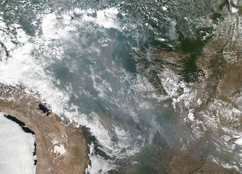
Fires in the Amazon Rainforest
This natural-color image shows smoke from fires in the Amazon rainforest spreading across several states within Brazil, including Amazonas, Mato Grosso, and Rondônia. The image was collected by our VIIRS (Visible Infrared Imaging Radiometer Suite) instrument aboard the Suomi NPP satellite (a joint-partnership between NASA and the National Oceanic and Atmospheric Administration) on August 20, 2019. It’s not unusual to see fires in Brazil at this time of year, but activity in the country’s largest state, Amazonas, has been above average. Many people use fire to maintain farmland and pastures or to clear land for other purposes.
Credits: NASA Worldview, Earth Observing System Data and Information System (EOSDIS).
Make sure to follow us on Tumblr for your regular dose of space: http://nasa.tumblr.com.
5 Ways the Moon Landing Changed Life on Earth
When Neil Armstrong took his first steps on the Moon 50 years ago, he famously said “that’s one small step for a man, one giant leap for mankind.” He was referring to the historic milestone of exploring beyond our own planet — but there’s also another way to think about that giant leap: the massive effort to develop technologies to safely reach, walk on the Moon and return home led to countless innovations that have improved life on Earth.
Armstrong took one small step on the lunar surface, but the Moon landing led to a giant leap forward in innovations for humanity.
Here are five examples of technology developed for the Apollo program that we’re still using today:
1. Food Safety Standards
As soon as we started planning to send astronauts into space, we faced the problem of what to feed them — and how to ensure the food was safe to eat. Can you imagine getting food poisoning on a spacecraft, hundreds of thousands of miles from home?
We teamed up with a familiar name in food production: the Pillsbury Company. The company soon realized that existing quality control methods were lacking. There was no way to be certain, without extensive testing that destroyed the sample, that the food was free of bacteria and toxins.
Pillsbury revamped its entire food-safety process, creating what became the Hazard Analysis and Critical Control Point system. Its aim was to prevent food safety problems from occurring, rather than catch them after the fact. They managed this by analyzing and controlling every link in the chain, from the raw materials to the processing equipment to the people handling the food.
Today, this is one of the space program’s most far-reaching spinoffs. Beyond keeping the astronaut food supply safe, the Hazard Analysis and Critical Point system has also been adopted around the world — and likely reduced the risk of bacteria and toxins in your local grocery store.

2. Digital Controls for Air and Spacecraft
The Apollo spacecraft was revolutionary for many reasons. Did you know it was the first vehicle to be controlled by a digital computer? Instead of pushrods and cables that pilots manually adjusted to manipulate the spacecraft, Apollo’s computer sent signals to actuators at the flick of a switch.
Besides being physically lighter and less cumbersome, the switch to a digital control system enabled storing large quantities of data and programming maneuvers with complex software.
Before Apollo, there were no digital computers to control airplanes either. Working together with the Navy and Draper Laboratory, we adapted the Apollo digital flight computer to work on airplanes. Today, whatever airline you might be flying, the pilot is controlling it digitally, based on the technology first developed for the flight to the Moon.

3. Earthquake-ready Shock Absorbers
A shock absorber descended from Apollo-era dampers and computers saves lives by stabilizing buildings during earthquakes.
Apollo’s Saturn V rockets had to stay connected to the fueling tubes on the launchpad up to the very last second. That presented a challenge: how to safely move those tubes out of the way once liftoff began. Given how fast they were moving, how could we ensure they wouldn’t bounce back and smash into the vehicle?
We contracted with Taylor Devices, Inc. to develop dampers to cushion the shock, forcing the company to push conventional shock isolation technology to the limit.
Shortly after, we went back to the company for a hydraulics-based high-speed computer. For that challenge, the company came up with fluidic dampers—filled with compressible fluid—that worked even better. We later applied the same technology on the Space Shuttle’s launchpad.
The company has since adapted these fluidic dampers for buildings and bridges to help them survive earthquakes. Today, they are successfully protecting structures in some of the most quake-prone areas of the world, including Tokyo, San Francisco and Taiwan.

4. Insulation for Space
We’ve all seen runners draped in silvery “space blankets” at the end of marathons, but did you know the material, called radiant barrier insulation, was actually created for space?
Temperatures outside of Earth’s atmosphere can fluctuate widely, from hundreds of degrees below to hundreds above zero. To better protect our astronauts, during the Apollo program we invented a new kind of effective, lightweight insulation.
We developed a method of coating mylar with a thin layer of vaporized metal particles. The resulting material had the look and weight of thin cellophane packaging, but was extremely reflective—and pound-for-pound, better than anything else available.
Today the material is still used to protect astronauts, as well as sensitive electronics, in nearly all of our missions. But it has also found countless uses on the ground, from space blankets for athletes to energy-saving insulation for buildings. It also protects essential components of MRI machines used in medicine and much, much more.

Image courtesy of the U.S. Marines
5. Healthcare Monitors
Patients in hospitals are hooked up to sensors that send important health data to the nurse’s station and beyond — which means when an alarm goes off, the right people come running to help.
This technology saves lives every day. But before it reached the ICU, it was invented for something even more extraordinary: sending health data from space down to Earth.
When the Apollo astronauts flew to the Moon, they were hooked up to a system of sensors that sent real-time information on their blood pressure, body temperature, heart rate and more to a team on the ground.
The system was developed for us by Spacelabs Healthcare, which quickly adapted it for hospital monitoring. The company now has telemetric monitoring equipment in nearly every hospital around the world, and it is expanding further, so at-risk patients and their doctors can keep track of their health even outside the hospital.

Only a few people have ever walked on the Moon, but the benefits of the Apollo program for the rest of us continue to ripple widely.
In the years since, we have continued to create innovations that have saved lives, helped the environment, and advanced all kinds of technology.
Now we’re going forward to the Moon with the Artemis program and on to Mars — and building ever more cutting-edge technologies to get us there. As with the many spinoffs from the Apollo era, these innovations will transform our lives for generations to come.
Make sure to follow us on Tumblr for your regular dose of space: http://nasa.tumblr.com.
All Eyes on the Sky for the August 21 Total Solar Eclipse
Just two months from now, the moon will completely block the sun’s face, treating part of the US to a total solar eclipse.

Everyone in North America will have the chance to see an eclipse of some kind if skies are clear. Anyone within a 70-mile-wide swath of land — called the path of totality — that stretches from Oregon to South Carolina will have the chance to see a total eclipse.

Throughout the rest of the continent, including all 50 United States — and even in parts of South America, Africa, Europe, and Asia — the moon will partially obscure the sun, creating a partial eclipse.

Photo credit: NASA/Cruikshank
An eclipse is one of nature’s most awesome sights, but safety comes first! When any part of the sun’s surface is exposed, use proper eclipse glasses (not sunglasses) or an indirect viewing method, like a pinhole projector. In the path of totality, it’s safe to look directly at the eclipse ONLY during the brief moments of totality.

During a solar eclipse, the moon passes between the sun and Earth, casting a shadow down on Earth’s surface. We’ve been studying the moon with NASA’s Lunar Reconnaissance Orbiter, and its precise mapping helped NASA build the most accurate eclipse map to date.

During a total solar eclipse, the moon blocks out the sun’s bright face, revealing the otherwise hidden solar atmosphere, called the corona. The corona is one of the sun’s most interesting regions — key to understanding the root of space weather events that shape Earth’s space environment, and mysteries such as why the sun’s atmosphere is so much hotter than its surface far below.

This is the first time in nearly 100 years that a solar eclipse has crossed the United States from coast to coast. We’re taking advantage of this long eclipse path by collecting data that’s not usually accessible — including studying the solar corona, testing new corona-observing instruments, and tracking how our planet’s atmosphere, plants, and animals respond to the sudden loss of light and heat from the sun.
We’ll be studying the eclipse from the ground, from airplanes, with research balloons, and of course, from space.
Three of our sun-watchers — the Solar Dynamics Observatory, IRIS, and Hinode, a joint mission led by JAXA — will see a partial eclipse from space. Several of our Earth-observing satellites will use the eclipse to study Earth under uncommon conditions. For example, both Terra and DSCOVR, a joint mission led by NOAA, will capture images of the moon’s shadow from space. Our Lunar Reconnaissance Orbiter will also turn its instruments to face Earth and attempt to track the moon’s shadow as it moves across the planet.

There’s just two months to go until August 21, so make your plans now for the big day! No matter where you are, you can follow the eclipse as it crosses the country with live footage from NASA TV.
Learn more about the upcoming total solar eclipse — including where, when, and how to safely experience it — at eclipse2017.nasa.gov and follow along on Twitter @NASASun.
Make sure to follow us on Tumblr for your regular dose of space: http://nasa.tumblr.com
Travel to Exotic Destinations in our Galaxy!
The planets beyond our solar system – exoplanets – are so far away, often trillions of miles, that we don’t have the technology to truly see them. Even the best photos show the planets as little more than bright dots. We’ve confirmed more than 5,000 exoplanets, but we think there are billions. Space telescopes like Hubble aren’t able to take photos of these far-off worlds, but by studying them in different wavelengths of light (colors), we’ve learned enough about conditions on these planets that we can illustrate them.

We know, thanks to the now-retired Spitzer Space Telescope, that there is a thick atmosphere on a planet called 55 Cancri e about 40 light-years away. And Hubble found silicate vapor in the atmosphere of this rocky world. We also know it’s scorching-close to its Sun-like star, so … lava. Lots and lots of lava. This planet is just one of the many that the James Webb Space Telescope will soon study, telling us even more about the lava world!
You can take a guided tour of this planet (and others) and see 360-degree simulations at our new Exoplanet Travel Bureau.
Travel to the most exotic destinations in our galaxy, including:
Kepler-16b, a planet with two suns.

Then there’s PSO J318.5-22, a world with no sun that wanders the galaxy alone. The nightlife would never end on a planet without a star.

TRAPPIST-1e, which will also be studied by the Webb Space Telescope, is one of seven Earth-sized planets orbiting a star about 40 light-years from Earth. It’s close enough that, if you were standing on this exoplanet, you could see our Sun as a star in the Leo constellation! You can also see it on the poster below: look for a yellow star to the right of the top person’s eye.

We haven’t found life beyond Earth (yet) but we’re looking. Meanwhile, we can imagine the possibility of red grass and other plants on Kepler-186f, a planet orbiting a red dwarf star.

We can also imagine what it might be like to skydive on a super-Earth about seven times more massive than our home planet. You would fall about 35% faster on a super-Earth like HD 40307g, making for a thrilling ride!

Any traveler is going to want to pick up souvenirs, and we have you covered. You can find free downloads of all the posters here and others! What are you waiting for? Come explore with us!

Make sure to follow us on Tumblr for your regular dose of space!
Image credits: NASA/JPL-Caltech
Exploring an Asteroid Without Leaving Earth

You may remember that back in February, four crew members lived and worked inside our Human Research Exploration Analog (HERA). That crew, made up of 4 women, simulated a 715-day journey to a Near-Earth asteroid. Then in May, a second crew of 4 – this time, 4 men, launched on their simulated journey to that same asteroid. These 30 day missions help our researchers learn how isolation and close quarters affect individual and group behavior. Studies like this at our Johnson Space Center prepare us for long duration space missions, like a trip to an asteroid or even to Mars. We now have a third crew, living and working inside the HERA. This is the spacecraft’s 11th crew. The mission began on June 11, and will end on August 10.
The crew members are currently living inside this compact, science-making house. But unlike in a normal house, these inhabitants won’t go outside for 30 days. Their communication with the rest of planet Earth will also be very limited, and they won’t have any access to internet. The only people they will talk with regularly are mission control and each other.

The HERA XI crew is made up of 3 men and 1 woman selected from the Johnson Space Center Test Subject Screening (TSS) pool. The crew member selection process is based on a number of criteria, including the same criteria for astronaut selection. The four would-be astronauts are:
• Tess Caswell
• Kyle Foster
• Daniel Surber
• Emmanuel Urquieta

What will they be doing?
The crew will test hardware prototypes to get “the bugs worked out” before they are used in off-Earth missions. They will conduct experiments involving plants, brine shrimp, and creating a piece of equipment with a 3D printer. After their visit to an asteroid, the crew will simulate the processing of soil and rocks they collected virtually. Researchers outside of the spacecraft will collect data regarding team dynamics, conflict resolution and the effects of extended isolation and confinement.

How real is a HERA mission?
When we set up an analog research investigation, we try to mimic as many of the spaceflight conditions as we can. This simulation means that even when communicating with mission control, there will be a delay on all communications ranging from 1 to 5 minutes each way, depending on how far their simulated spacecraft is from Earth.
Obviously we are not in microgravity, so none of the effects of microgravity on the human or the vehicle can be tested. You can simulate isolation to a great degree – although the crew knows they are note really isolated from humanity, the communications delays and ban from social media help them to suspend reality. We emulate confinement and the stress that goes along with it.
Scientists and researchers use analogs like HERA to gather more data for comparison to data collected aboard the space station and from other analogs so they can draw conclusions needed for a real mission to deep space, and one day for a journey to Mars.

A few other details:
The crew follows a timeline that is similar to one used for the ISS crew.
They work 16 hours a day, Monday through Friday. This includes time for daily planning, conferences, meals and exercises.
They will be growing and taking care of plants and brine shrimp, which they will analyze and document.
Past HERA crew members wore a sensor that recorded heart rate, distance, motion and sound intensity. When crew members were working together, the sensor would also record their proximity as well, helping investigators learn about team cohesion.
Researchers also learned about how crew members react to stress by recording and analyzing verbal interactions and by analyzing “markers” in blood and saliva samples.
As with the 2 earlier missions this year, this mission will include 22 individual investigations across key human research elements. From psychological to physiological experiments, the crew members will help prepare us for future missions.

Want a full, 360 degree look at HERA? Check out and explore the inside of the habitat.
For more information on our Human Research Program, visit: www.nasa.gov/hrp.
Make sure to follow us on Tumblr for your regular dose of space: http://nasa.tumblr.com
Science in space

This week on NASA Explorers, we’re aboard the International Space Station!

Now that our scientists’ experiment has made it to space, it’s time to see how their samples behave in microgravity.

See how astronauts conduct science in space, while a team back here on Earth conducts their own piece of the project. Watch the episode here:
Follow NASA Explorers on Facebook to catch new episodes of season 4 every Wednesday!
Make sure to follow us on Tumblr for your regular dose of space: http://nasa.tumblr.com
Space Missions Come Together in Colorado
Our leadership hit the road to visit our commercial partners Lockheed Martin, Sierra Nevada Corp. and Ball Aerospace in Colorado. They were able to check the status of flight hardware, mission operations and even test virtual reality simulations that help these companies build spacecraft parts.
Let’s take a look at all the cool technology they got to see…
Lockheed Martin
Lockheed Martin is the prime contractor building our Orion crew vehicle, the only spacecraft designed to take humans into deep space farther than they’ve ever gone before.

Acting NASA Deputy Administrator Lesa Roe and Acting NASA Administrator Robert Lightfoot are seen inside the CHIL…the Collaborative Human Immersive Laboratory at Lockheed Martin Space Systems in Littleton, Colo. Lockheed Martin’s CHIL enables collaboration between spacecraft design and manufacturing teams before physically producing hardware.

Cool shades! The ability to visualize engineering designs in virtual reality offers tremendous savings in time and money compared to using physical prototypes. Technicians can practice how to assemble and install components, the shop floor can validate tooling and work platform designs, and engineers can visualize performance characteristics like thermal, stress and aerodynamics, just like they are looking at the real thing.

This heat shield, which was used as a test article for the Mars Curiosity Rover, will now be used as the flight heat shield for the Mars 2020 rover mission.
Fun fact: Lockheed Martin has built every Mars heat shield and aeroshell for us since the Viking missions in 1976.

Here you can see Lockheed Martin’s Mission Support Area. Engineers in this room support six of our robotic planetary spacecraft: Mars Odyssey, Mars Reconnaissance Orbiter, MAVEN, Juno, OSIRIS-REx and Spitzer, which recently revealed the first known system of seven Earth-size planets around a single star, TRAPPIST-1. They work with NASA centers and the mission science teams to develop and send commands and monitor the health of the spacecraft.
See all the pictures from the Lockheed Martin visit HERE.
Sierra Nevada Corporation
Next, Lightfoot and Roe went to Sierra Nevada Corporation in Louisville, Colo. to get an update about its Dream Chaser vehicle. This spacecraft will take cargo to and from the International Space Station as part of our commercial cargo program.

Here, Sierra Nevada Corporation’s Vice President of Space Exploration Systems Steve Lindsey (who is also a former test pilot and astronaut!) speaks with Lightfoot and Roe about the Dream Chaser Space System simulator.

Lightfoot climbed inside the Dream Chaser simulator where he “flew” the crew version of the spacecraft to a safe landing. This mock-up facility enables approach-and-landing simulations as well as other real-life situations.

See all the images from the Sierra Nevada visit HERE.
Ball Aerospace
Lightfoot and Roe went over to Ball Aerospace to tour its facility. Ball is another one of our commercial aerospace partners and helps builds instruments that are on NASA spacecraft throughout the universe, including the Hubble Space Telescope and the New Horizons mission to Pluto. Ball designed and built the advanced optical technology and lightweight mirror system that will enable the James Webb Space Telescope to look 13.5 billion years back in time.

Looking into the clean room at Ball Aerospace’s facility in Boulder, Colo., the team can see the Ozone Mapping Profiler Suite. These sensors are used on spacecraft to track ozone measurements.

Here, the group stands in front of a thermal vacuum chamber used to test satellite optics. The Operation Land Imager-2 is being built for Landsat 9, a collaboration between NASA and the U.S. Geological Survey that will continue the Landsat Program’s 40-year data record monitoring the Earth’s landscapes from space.
See all the pictures from the Ball Aerospace visit HERE.
We recently marked a decade since a new era began in commercial spaceflight development for low-Earth orbit transportation. We inked agreements in 2006 to develop rockets and spacecraft capable of carrying cargo such as experiments and supplies to and from the International Space Station. Learn more about commercial space HERE.
Make sure to follow us on Tumblr for your regular dose of space: http://nasa.tumblr.com
Local D.C. Artists Celebrate Mary W. Jackson's Legacy
On June 24, 2020, NASA announced the agency’s headquarters building in Washington, D.C., was to be named after Mary W. Jackson to celebrate her life and legacy. We collaborated with Events DC to create artwork inspired by Jackson’s story as the agency’s first Black female engineer.
Take a look at how six local female artists interpreted Jackson’s place in history through their individual creative lenses.
1. Trap Bob

“To see Mary [W.] Jackson be so successful and to get the recognition that she deserves, it hits home for me in a couple ways.”
Tenbeete Solomon AKA Trap Bob is a visual artist, illustrator, and animator based in Washington, D.C.
“Art is so important across the board because it’s really a form of documentation,” says Trap Bob. “It’s creating a form of a history… that’s coming from the true essence of what people feel in the communities.”
2. Jamilla Okubo

“People can relate to things that may seem foreign to them through imagery.”
Jamilla Okubo is an interdisciplinary artist exploring the intricacies of belonging to an American, Kenyan, and Trinidadian identity.
“I wanted to create a piece that represented and celebrated and honored Mary [W.] Jackson, to remember the work that she did,” says Okubo.
3. Tracie Ching

“This is a figure who actually looks like us, represents us.”
Tracie Ching is an artist and self-taught illustrator working in Washington, D.C.
“The heroes and the figures that we had presented to us as kids didn’t ever look like me or my friends or the vast majority of the people around me,” says Ching.
4. Jennifer White-Johnson

"To be even a Black artist making artwork about space — it’s because of her triumphs and her legacy that she left behind.”
Jennifer White-Johnson is an Afro-Latina, disabled designer, educator, and activist whose work explores the intersection of content and caregiving with an emphasis on redesigning ableist visual culture.
“My piece is… a take on autistic joy because my son is autistic," says White-Johnson. "And I really just wanted to show him… in a space where we often don’t see Black disabled kids being amplified.”
5. Kimchi Juice

“In my art, I try to highlight really strong and empowering women."
Julia Chon, better known by her moniker “Kimchi Juice,” is a Washington, D.C.-based artist and muralist.
“As minority women, we are too often overlooked and under recognized for the work and time that we give," says Kimchi Juice. "And so to see Mary W. Jackson finally being given this recognition is fulfilling to me.”
6. OG Lullabies
“I wanted when one listens to it, to feel like there is no limit.”
OG Lullabies is a Washington D.C. songwriter, multi-instrumentalist, including violin and electronics.
“When you look back at history… art is the color or the sound in the emotions that encapsulated the moment,” says OG Lullabies. “It’s the real human experience that happens as time passes.”
Make sure to follow us on Tumblr for your regular dose of space: http://nasa.tumblr.com.

Exploring Hell... up for the challenge?
Venus is an EXTREME world, and we’re calling on YOU to help us explore it! NASA Jet Propulsion Laboratory is running a public challenge to develop an obstacle avoidance sensor for a possible future Venus rover.
With a surface temperature in excess of 840 degrees Fahrenheit and a surface pressure 92 times that of Earth, Venus can turn lead into a puddle and crush a nuclear-powered submarine with ease. While many missions have visited our sister planet, only about a dozen have made contact with the surface of Venus before succumbing to the oppressive heat and pressure after just about more than an hour.
The “Exploring Hell: Avoiding Obstacles on a Clockwork Rover” challenge is seeking the public’s designs for a sensor that could be incorporated into the design concept. The winning sensor could be the primary mechanism by which the rover detects and navigates around obstructions.
Award: 1st Place - $15,000; 2nd Place - $10,000; 3rd Place - $5,000
Open Date: February 18, 2020 ––––––––– Close Date: May 29, 2020
-
 wingeert2olice liked this · 4 months ago
 -
 afsludmudfdadlack liked this · 1 year ago
 -
 nottoonicehoebutloveableaf reblogged this · 3 years ago
 -
 perennii liked this · 3 years ago
 -
 secretcherimaybe liked this · 3 years ago
 -
 scrumptioushairdoghostoperator liked this · 3 years ago
 -
 miroveha liked this · 4 years ago
 -
 doormanjp liked this · 4 years ago
 -
 bright-trash liked this · 4 years ago
 -
 ishmamahmed liked this · 4 years ago
 -
 comeoffage reblogged this · 4 years ago
 -
 cardstumble reblogged this · 4 years ago
 -
cardstumble liked this · 4 years ago
-
 thesooks liked this · 4 years ago
Explore the universe and discover our home planet with the official NASA Tumblr account
1K posts